4.2 Data and Study Area
The Philippine Atmospheric, Geophysical, and Astronomical Services Administration (PAGASA), the country’s weather agency, maintains a network of 10 ground radars all over the country, of which 8 are single-polarization S-Band radars and 2 are dual-polarization C-Band radars. Two of the longest running radars are Subic and Tagaytay. Between the two radars lies Manila Bay, bordered on the east by Metro Manila, the country’s most densely populated area at approximately 13 Million inhabitants. This region of overlap regularly experiences torrential rains from monsoon and typhoons extending for several days (M. Heistermann et al. 2013; Lagmay et al. 2015).
| Subic Radar | Tagaytay Radar | |
|---|---|---|
| Bandwidth | S-Band | C-Band |
| Polarization | Single-pol | Dual-pol |
| Position (lat/lon) | 14.822N 120.363E | 14.123N 120.974E |
| Altitude | 532 m a.s.l. | 752 m a.s.l. |
| Maximum Range | 120 km | 120 |
| Azimuth Resolution | 1 | 1 |
| Gate length | 500 m | 500 m |
| Number of elevation angles | 14 | 14 |
| Elevation angles | 0.5, 1.5, 2.4, 3.4, 4.3, 5.3, 6.2, 7.5, 8.7, 10, 12, 14, 16.7, 19.5 | 0.5, 1.5, 2.4, 3.4, 4.3, 5.3, 6.2, 7.5, 8.7, 10, 12, 14, 16.7, 19.5 |
| Volume cycle interval | 8 minutes | 15 minutes |
| Start of operation | 2012 | 2012 |
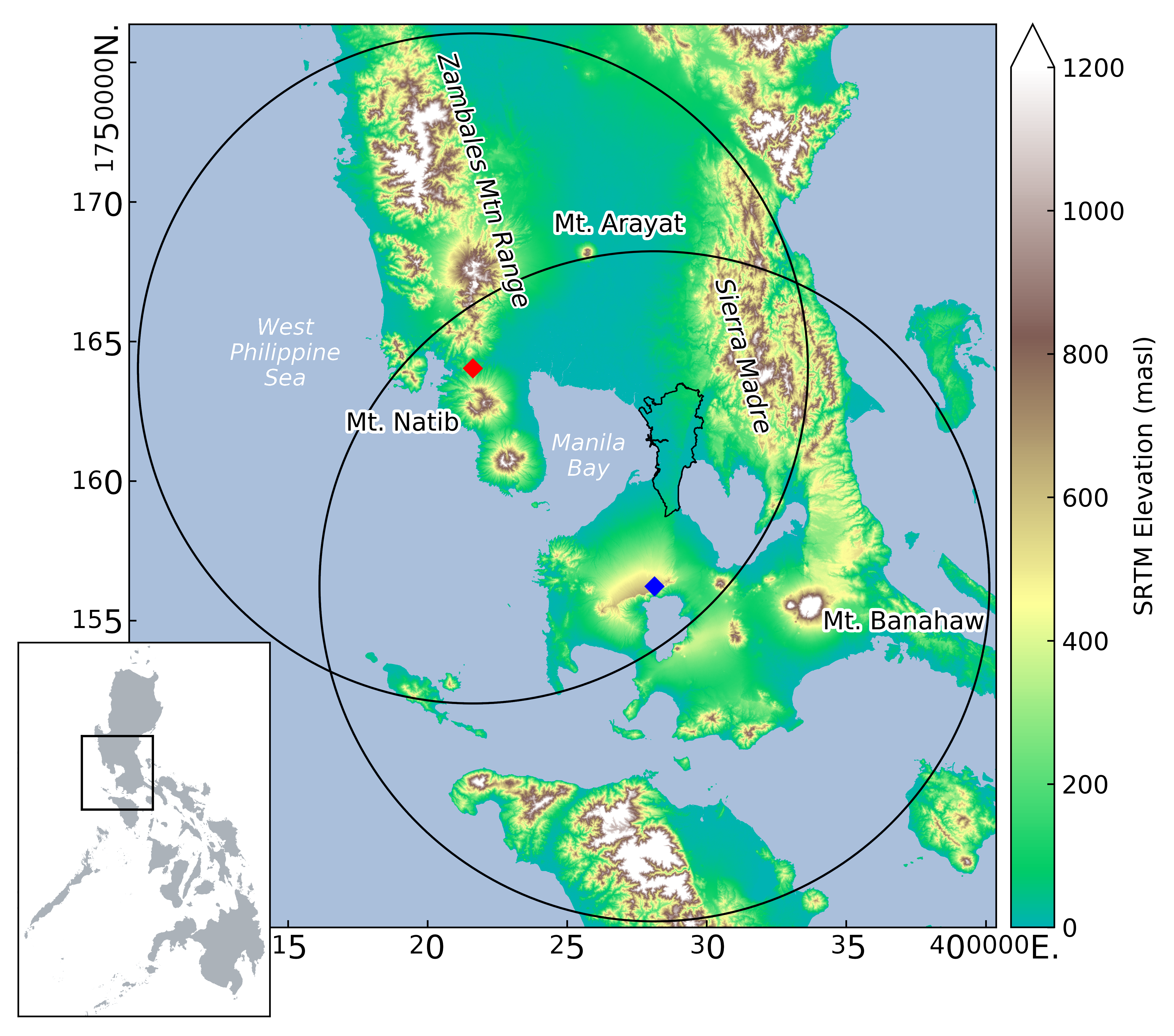
Figure 4.1: Locations of the Subic (red diamond) and Tagaytay (blue diamond) radars showing the 120 km range with the region of overlap. Metropolitan Manila is outlined in black beside Manila Bay. The relative location of the study area with respect to the Philippines is shown in the inset
4.2.1 Subic radar (SUB)
The Subic radar is a single-polarization S-band radar situated on top of a hill at 532 m a.s.l. in the municipality of Bataan (location: 14.82\(^{\circ}\)N, 120.36\(^{\circ}\)E) (see Figure 4.1). To its north lies the Zambales Mountains (highest peak: 2037 m a.s.l.) and to its south stands Mt. Natib (1253 m a.s.l.). The Sierra Madre Mountains run along the eastern part of the Luzon Island, at the far-east end of the radar coverage. Technical specifications are available in Table 4.1. Please note that Subic sweeps at 1.5 and 2.4 degree elevation were excluded for the years 2013 and 2014, due to apparently erratic and inconsistent behaviour.
4.2.2 Tagaytay radar (TAG)
Located about 100 km across the Manila Bay from the Subic radar is the Tagaytay radar, a dual-polarized C-Band radar. It sits along the Taal Volcano caldera ridge at 752 m a.s.l. in the municipality of Batangas. The radar coverage also includes the southern part of the Sierra Madre Mountains. Technical specifications are available in Table 4.1.
Data during the rainy seasons of 2012–2014 and 2016 are used in this study. The scanning setup for Tagaytay was experimentally changed during 2015 and reverted back in 2016. In order to ensure homogeneity in the GR intercomparison, we excluded the year 2015 from the analysis.
4.2.3 Spaceborne precipitation radar
Spaceborne radar data were collected from TRMM 2A23 and 2A25 version 7 (NASA, 2017) for overpass events in 2012–2014, and GPM 2AKu version 5A products (Iguchi et al. 2010) from 2014–2016, during the rainy season of June to December. The data were downloaded from NASA’s Precipitation Processing System (PPS) through the STORM web interface (https://storm.pps.eosdis.nasa.gov/storm/). The parameters of TRMM/GPM extracted for the analysis are the same as specified in Table 3 of Warren et al. (2018).
References
Heistermann, M., I. Crisologo, C. C. Abon, B. A. Racoma, S. Jacobi, N. T. Servando, C. P. C. David, and A. Bronstert. 2013. “Brief Communication "Using the New Philippine Radar Network to Reconstruct the Habagat of August 2012 Monsoon Event Around Metropolitan Manila".” Nat. Hazards Earth Syst. Sci. 13 (3): 653–57. https://doi.org/10.5194/nhess-13-653-2013.
Iguchi, Toshio, Shinta Seto, Robert Meneghini, Naofumi Yoshida, Jun Awaka, and Takuji Kubota. 2010. “GPM/DPR Level-2 Algorithm Theoretical Basis Document.” NASA Goddard Space Flight Center, Greenbelt, MD, USA, Tech. Rep.
Lagmay, Alfredo Mahar F., Gerry Bagtasa, Irene A. Crisologo, Bernard Alan B. Racoma, and Carlos Primo C. David. 2015. “Volcanoes Magnify Metro Manila’s Southwest Monsoon Rains and Lethal Floods.” Frontiers in Earth Science 2: 36. https://doi.org/10.3389/feart.2014.00036.