3.2 Data
3.2.1 Spaceborne precipitation radar
Precipitation radar data were gathered from TRMM 2A23 and 2A25 version 7 products (NASA 2017a) for overpass events intersecting with the Subic ground radar coverage from 1 June 2012 to 30 September 2014, and GPM 2AKu version 5A products (Iguchi et al. 2010) from 1 June 2014 to 31 December 2016. Ka-band observations have not been considered due to higher susceptibility to attenuation, and a limited validity of Rayleigh scattering in a substantial portion of rainfall cases (Baldini, Chandrasekar, and Moisseev 2012). From the collection of overpasses within these dates, only 183 TRMM overpasses and 103 GPM passes were within the radar coverage. The data were downloaded from NASA’s Precipitation Processing System (PPS) through the STORM web interface (https://storm.pps.eosdis.nasa.gov/storm/) on 15 February 2018 for TRMM and 14 June 2018 for GPM. The parameters of TRMM/GPM extracted for the analysis are the same as Warren et al. (2018; their Table 3).
It is important to note that, at the time of writing, changes in calibration parameters applied in the GPM Version 5 products resulted in an increase of +1.1 dB from the corresponding TRMM version 7 products (NASA 2017b).
3.2.2 Ground radar
The Philippine Atmospheric, Geophysical, and Astronomical Services Administration (PAGASA) maintains a nationwide network of 10 weather radars, 8 of which are single-polarization S-band radars and 2 are dual-polarization C-band radars. The Subic radar, which covers the greater Metropolitan Manila area, has the most extensive set of archived data. The radar coverage includes areas that receive some of the highest mean annual rainfall in the country.
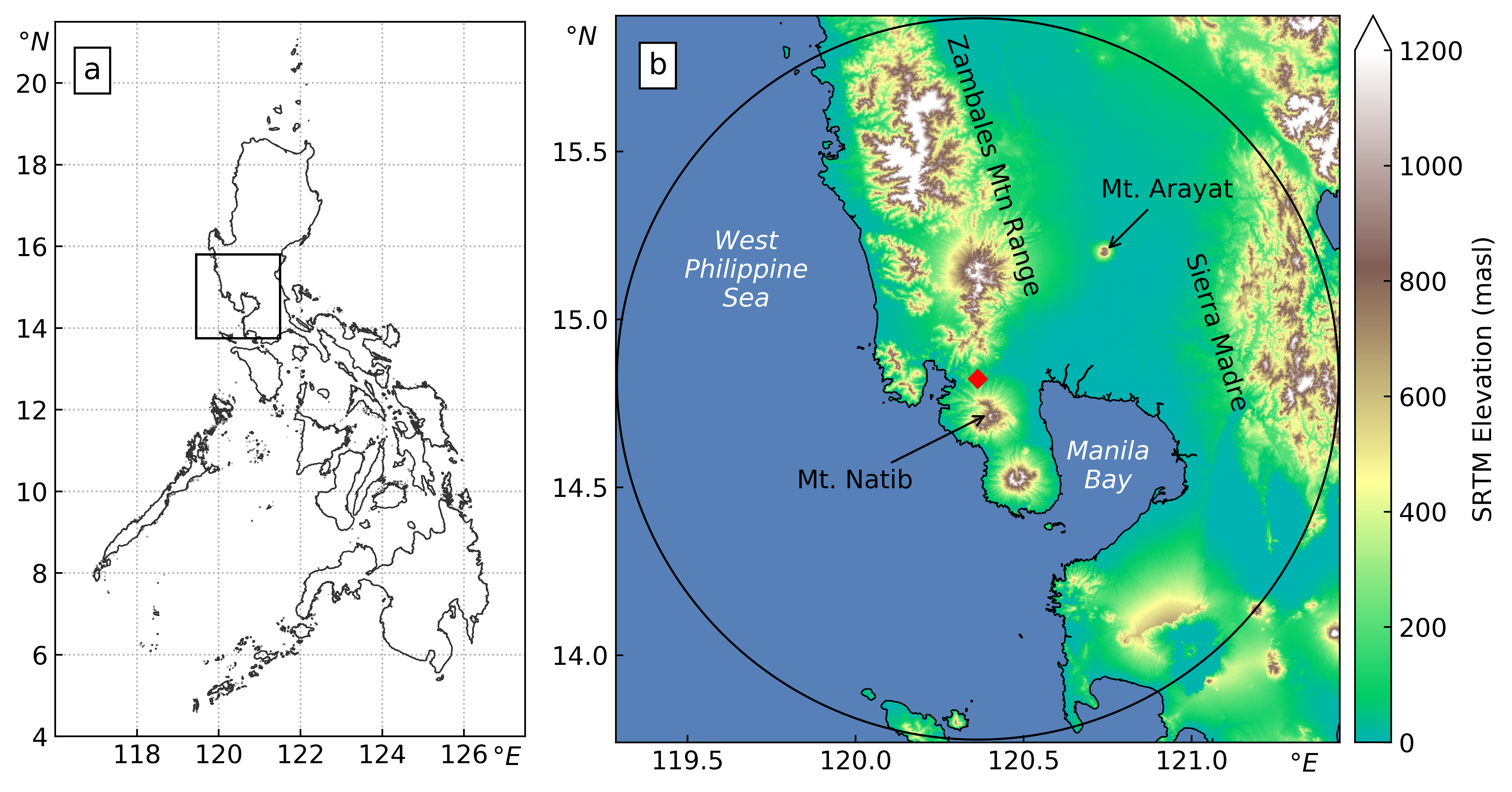
Figure 3.1: (a) Map of the Philippines showing the region of study and (b) the 120km coverage of the Subic radar (location marked with red diamond) with the SRTM digital elevation model of the surrounding area.
The Subic radar sits on top of a hill at 532 m.a.s.l. in the municipality of Bataan, near the border with Zambales (location: 14.82 \(^{\circ}\)N, 120.36 \(^{\circ}\)E) (see Figure 3.1). To its south stands Mt. Natib (1253 m.a.s.l.) and to its north run the Zambales Mountains (the highest peak stands at 2037 m.a.s.l.). To the west is the Redondo Peninsula in the southern part of the Zambales province, where some mountains are also situated. Almost half of the coverage of the Subic radar is water, with Manila Bay to its south-east and the West Philippine Sea to the west. Technical specifications of the radar are summarized in Table 3.1. Data from April 2012 to December 2016 were obtained from PAGASA. Throughout the 5 years the scan strategy remained the same, except for 2015 when it was limited to only three elevation angles per volume due to hardware issues. The standard scanning strategy was re-implemented in 2016.
| Subic Radar | Tagaytay Radar | |
|---|---|---|
| Bandwidth | S-Band | C-Band |
| Polarization | Single-pol | Dual-pol |
| Position (lat/lon) | 14.822N 120.363E | 14.123N 120.974E |
| Altitude | 532 m a.s.l. | 752 m a.s.l. |
| Maximum Range | 120 km | 120 |
| Azimuth Resolution | 1 | 1 |
| Gate length | 500 m | 500 m |
| Number of elevation angles | 14 | 14 |
| Elevation angles | 0.5, 1.5, 2.4, 3.4, 4.3, 5.3, 6.2, 7.5, 8.7, 10, 12, 14, 16.7, 19.5 | 0.5, 1.5, 2.4, 3.4, 4.3, 5.3, 6.2, 7.5, 8.7, 10, 12, 14, 16.7, 19.5 |
| Volume cycle interval | 8 minutes | 15 minutes |
| Start of operation | 2012 | 2012 |
References
Baldini, Luca, V. Chandrasekar, and Dmitri Moisseev. 2012. “Microwave Radar Signatures of Precipitation from S-Band to Ka-Band: Application to GPM Mission.” European Journal of Remote Sensing 45 (1): 75–88. https://doi.org/10.5721/EuJRS20124508.
Iguchi, Toshio, Shinta Seto, Robert Meneghini, Naofumi Yoshida, Jun Awaka, and Takuji Kubota. 2010. “GPM/DPR Level-2 Algorithm Theoretical Basis Document.” NASA Goddard Space Flight Center, Greenbelt, MD, USA, Tech. Rep.
NASA. 2017a. “Precipitation Processing System Tropical Rainfall Measuring Mission File Specification for TRMM Products.” https://pps.gsfc.nasa.gov/Documents/filespec.TRMM.V7.pdf.
NASA. 2017b. “Release Notes for the PR Level 1 Products.” https://pps.gsfc.nasa.gov/Documents/ReleaseNote_PU1_productV05.pdf.